
Pacific Crest Trail to Loves Falls
General Information
•Mileage: 2 miles one way
•Elevation: 4400 to 5000 feet
•Difficulty: Moderate
•Use Level: Moderate
•Season: May through October
Access
At the Northeast end of Sierra City turn off Highway 49 onto Wild Plum Road at the sign for the Wild Plum Campground. (The sign is located just opposite the Yuba River Inn.) Follow Wild Plum Road for 1 mile to a new trailhead parking facility. Walk the trail from the trailhead 1/8 mile where it crosses the road. This is the intersection of the Wild Plum Loop Trail.
Trail Description
The trail starts at either the new trailhead parking facility or at the upper end of the campground near Unit 31. The first mile follows the Wild Plum Loop Trail. From the trailhead parking facility walk the trail for 1/8 mile to where it crosses the road. Take the road across the bridge and through the campground, climbing moderately through a mixed conifer forest. After approximately 1/2 mile you will see a creek on your left which originates on the slopes above the Hilda Mine. Here the well marked trail leaves the road to the left. It remains relatively flat for another 1/2 mile offering an excellent view of the towering Sierra Buttes before arriving at the footbridge across Haypress Creek.
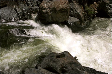
The trail meets the Pacific Crest Trail at the bridge. Cross the bridge and follow the Pacific Crest Trail through a lightly forested area which provides several more glimpses of the Sierra Buttes. After about 1.5 miles you will reach the prime attraction of this hike: Loves Falls. A massive bridge vaults the North Yuba River. The river has cut a mini-gorge through the metavolcanic rock. It thunders from fall to fall with a deep pool lying at the base of each fall. The Loves Falls hike ends here, although the Pacific Crest Trail continues toward the Sierra Buttes and eventually to the Canadian border. When returning to the trailhead we suggest you hike back on the Pacific Crest Trail about 3/8 mile to a fork on your right clearly marked for Wild Plum Campground. This is the return of the Wild Plum Loop Trail which guides you down to a flat area near the old Wild Plum Guard Station (now closed). In a few more minutes you will be at the road which you can take to the left over the bridge and back to the campground or you can take the trail across the road back to the new trailhead parking facility.
For an easy family hike, choose the Sand
Pond Interpretive Trail.
For a moderate year-round hike, try the Canyon
Creek Trail.
For a real challenge, there's Sierra
Buttes Lookout.
For a panoramic view, follow the Lakes
Basin Ridge Trail.
For enchanting forests and rushing creeks, try the Second
and Third Divide Trails.